

Torbalı Municipality and Marketplace Architectural Project:
"URBAN CONTINUITY"
TORBALI
Torbalı district, which is connected to İzmir province, is located in the south east of İzmir province. District; It is in an important place with its geographical location, transportation advantage and proximity to markets. It is also developed in terms of agriculture, animal husbandry and industry. The district is 45 km from Izmir city center. The arrival of the İZBAN (İzmir Commuter Train System) line to the district made the city more busy and strengthened its relationship with the city center of İzmir. Besides these positive results of IZBAN line in Torbalı scale; Looking at the city, it is observed that the line divides the city center into two regions and there is a disconnection between these regions.
In terms of its design area location, it is located in the center of Torbalı at an important benchmark point in the city. In the field of design; Currently, there is an open area that is used for a market function on a certain day of the week and defined by the top cover element and Torbalı Municipality Building is located nearby. It has been observed that the İZBAN line, which is close to the land, makes the city more busy and divides the city into two separate regions and creates a disconnection between these regions; While there is a residential area on one side, on the other hand, there is a region where commercial buildings are concentrated, including the city center. There is currently an underpass for this situation. The narrow and dysfunctional underpass located near the area subject to the competition was enlarged and associated with the square, and its relationship with the city center was strengthened by dissolving at the minus level. Thus, the disconnection between the areas divided into two separate regions is eliminated and continuity is provided.
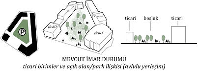
The design area is located in an area where the buildings used for commercial functions are concentrated. The area is located on an important commercial axis in the city. When the island-based structuring of the commercial buildings in the zoning plan was examined, it was observed that the buildings mostly settled on the island periphery and formed a courtyard with a green area in the middle. Among the areas subject to the competition, there are commercial buildings on the periphery of area A, which will host the market on Thursdays. Based on the existing construction on the building blocks formed by the commercial buildings in the region, an urban void has been created in area A that will breathe the city. The market area, which has a commercial function, was kept at the same level with the street, and the city square, which is an urban space, was cut off from this area by reducing the negative quota. Thus, the city square, which is separated from areas with commercial intensity, was both privatized and connected to the municipality building in area B with an underpass, providing continuity between areas A and B. In addition, by establishing a connection from the city square to the C area with the underpass, the citizens of the city were provided to reach the other side of the İZBAN line without interruption. Thus, a continuity has been achieved between the areas subject to the competition.
LANDSCAPE EDITING AND MARKET SPACE
Landscape elements were created in area A with a 5 * 5 meter gridal system. The landscaping elements on the 5 * 5 axes were brought together in different sizes to create definitions and boundaries between areas. Transitions and approaches between these borders and areas were expressed more effectively. Among the Gridal system, greens are partly included. The market area has been designed in a way to allow the city dwellers to use day and night alternatives on days when there is no market. Commercial units have been integrated into the market area to support daytime use. On days when there is no market, commercial units are located on the periphery in order to use the area actively. 8 * 8 meter grids were used in the arrangement of the market area and each market unit was arranged to fit into these grids. Thus, the continuity in landscaping has been provided with the market area. The garbage collection system (monşarj) associated with the basement in the market area has been resolved. The top cover of the market area was created by moving the gridal organization on the ground to the upper surface, and the top cover was partially torn and evacuated for the units to get light and air.
DESIGN APPROACH AND CONSTRUCTION
While examining the areas subject to the competition, it was observed that the areas were disconnected from each other. Areas A and B are located to the east of the İZBAN line, while area C is to the west of this line. There is also İsmet Paşa Street between area A and area B. A design approach has been adopted that will eliminate this disconnection between the areas and ensure continuity in transportation and visual relations. The project area has a flat topography. By leveling in area A, the market area is positioned at street level and a city square was created at the lower elevation (-4.50 m elevation). Continuity in transportation has been ensured by making connections with underpasses from this city square to areas B and C. The town hall is located in area B. While the municipality building is settled on the land, it is essential to establish a visual relationship with the city square. While the municipality building masses, service units are separated from the directorates through a transparent gallery system. Gallery and circulation areas establish a visual relationship with the city square. While the mass was rising in harmony with the surrounding buildings, the visual relationship with the city square was strengthened by terracing the mass. In line with the requirement program, while units with public functions are placed in the lower elevations, more private areas have been placed in the upper elevations. On the 1st basement floor (-4.50 m elevation), the entrance and reception areas belonging to the Municipality building are located and these spaces are directly connected with the city square, allowing the citizens to reach the Municipality building in an inviting and uninterrupted manner. At the same time, the citizen coming from the city square is included in the municipality building and can reach 4519th Street (the street to the south of area B) without interruption. There is also a green area in area B. The dining hall is located on the ground floor and associated with this green area and the green area has been activated.
A restaurant and parking lot are designed in the C area. While the restaurant is located, it faces the green area on the parcel to the south of area C. The parking lot has been resolved in the area behind the restaurant. The restaurant mass has been terraced. A visual relationship was established with the city square with the suggestion of terracing and amphitheater. On the other hand, the underpass extending from the city square to the C area is connected to the street (3566. Street) to the south of the C area, thus providing urban continuity.


GET IN TOUCH:
Tel: +90545 327 43 54
E-mail*
CONTACT US:
Message
Name*